


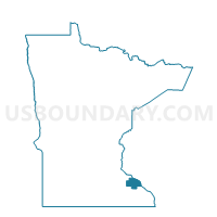
Zumbro Falls Voting District, Wabasha County, Minnesota
About
Outline

Summary
| Unique Area Identifier | 604687 |
| Name | Zumbro Falls Voting District |
| County | Wabasha County |
| State | Minnesota |
| Area (square miles) | 0.61 |
| Land Area (square miles) | 0.58 |
| Water Area (square miles) | 0.03 |
| % of Land Area | 95.12 |
| % of Water Area | 4.88 |
| Latitude of the Internal Point | 44.28782400 |
| Longtitude of the Internal Point | -92.42721700 |
Maps


Graphs
Select a template below for downloading or customizing gragh for Zumbro Falls Voting District, Wabasha County, Minnesota


Neighbors
Neighoring Voting District (by Name) Neighboring Voting District on the Map
- Chester Twp. Voting District, Wabasha County, MN
- Gillford Twp. Voting District, Wabasha County, MN
- Hyde Park Twp. Voting District, Wabasha County, MN
- Zumbro Twp. Voting District, Wabasha County, MN
Top 10 Neighboring County Subdivision (by Population) Neighboring County Subdivision on the Map
- Zumbro township, Wabasha County, MN (722)
- Gillford township, Wabasha County, MN (572)
- Chester township, Wabasha County, MN (455)
- Hyde Park township, Wabasha County, MN (286)
- Zumbro Falls city, Wabasha County, MN (207)